
- Start >
- Groundwater >
- Waterlevel of upper layer >
- Obere Donau >
- ASCHELSRIED B 6 >
- Chart of total period

Chart of total period ASCHELSRIED B 6
Groundwater levels of the total period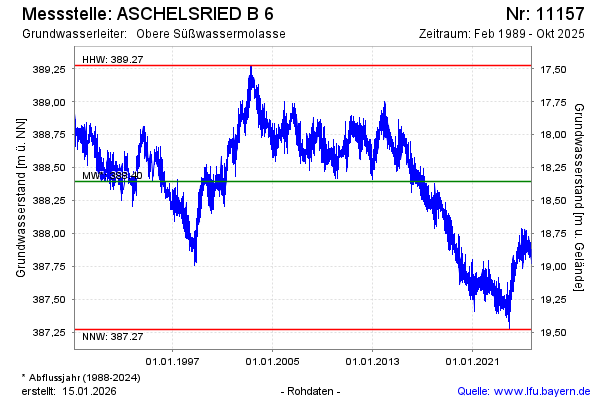
Groundwater level [m above sealevel]: 388.00
Distance to surface [m]: 18.75
Last value from 09.10.2024 14:00
Ground level [m above sealevel]: 406.75
| Date | Groundwater level [m above sealevel] |
|---|---|
| 09.10.2024 | 387.95 |
| 08.10.2024 | 387.96 |
| 07.10.2024 | 387.93 |
| 06.10.2024 | 387.91 |
| 05.10.2024 | 387.87 |
| 04.10.2024 | 387.88 |
| 03.10.2024 | 387.90 |
| 02.10.2024 | 387.94 |
© Bayerisches Landesamt für Umwelt 2024