
- Start >
- Groundwater >
- Waterlevel of upper layer >
- Unterer Main >
- LOHR A. MAIN/FARBMUEH. >
- Current data

Current data LOHR A. MAIN/FARBMUEH.
Groundwater levels of the last 12 months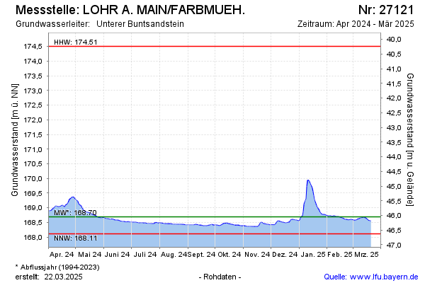
Groundwater level [m above sealevel]: 168.30
Distance to surface [m]: 46.44
Last value from 15.12.2025 10:00
Ground level [m above sealevel]: 214.74
| Date | Groundwater level [m above sealevel] |
|---|---|
| 15.12.2025 | 168.30 |
| 14.12.2025 | 168.29 |
| 13.12.2025 | 168.30 |
| 12.12.2025 | 168.31 |
| 11.12.2025 | 168.31 |
| 10.12.2025 | 168.33 |
| 09.12.2025 | 168.34 |
| 08.12.2025 | 168.33 |
© Bayerisches Landesamt für Umwelt 2025