
- Start >
- Groundwater >
- Waterlevel of upper layer >
- Untere Donau >
- Mallersdorf Q6 >
- Current data

Current data Mallersdorf Q6
Groundwater levels of the last 12 months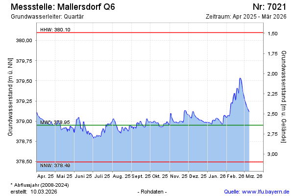
note
GW Messstelle im Grundnetz
Groundwater level [m above sealevel]: 379.16
Distance to surface [m]: 2.43
Last value from 16.12.2024 08:00
Ground level [m above sealevel]: 381.59
| Date | Groundwater level [m above sealevel] |
|---|---|
| 16.12.2024 | 379.17 |
| 15.12.2024 | 379.18 |
| 14.12.2024 | 379.21 |
| 13.12.2024 | 379.24 |
| 12.12.2024 | 379.27 |
| 11.12.2024 | 379.30 |
| 10.12.2024 | 379.34 |
| 09.12.2024 | 379.38 |
© Bayerisches Landesamt für Umwelt 2024