
- Start >
- Rivers >
- Discharge >
- Oberer Main - Elbe >
- Trunstadt >
- Master data

Master data Trunstadt
Site number: 24012203
District: Bamberg
Operator:  Wasserstraßen und Schifffahrtsamt Main
Body of water: Main
Catchment: 12012.30 km2
River chainage: 378.44 km
Easting: 625973 (ETRS89 / UTM Zone 32N)
Northing: 5532289
Gauge zero point: 223.36 m NHN (DHHN2016)
Picture of the measurement site
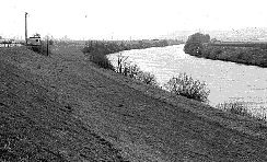
Location of the station Trunstadt / Main
| Measurement site | Category |
|---|---|
 Schenkenau Schenkenau | Rivers: Runoff, Waterlevel, Water temperature, Water temperature |
| Heinersdorf | Rivers: Runoff, Waterlevel |
| Schönbrunn | Rivers: Runoff, Waterlevel |
| Vorra | Rivers: Runoff, Waterlevel |
© Bayerisches Landesamt für Umwelt 2024