
- Start >
- Rivers >
- Waterlevel >
- Bayern >
- Türkheim >
- Chart of year

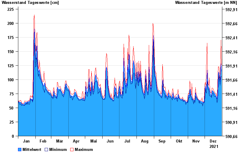
Chart of year Türkheim / Wertach
Waterlevel from 01.01.2021 to 31.12.2021
note
Beeinflussung durch Kraftwerksbetrieb
- 02.06.1906 Wasserstand: 503 cm
- 16.06.1910 Wasserstand: 500 cm
- 26.07.1906 Wasserstand: 495 cm
- 06.04.1901 Wasserstand: 480 cm
- 31.05.1940 Wasserstand: 479 cm
| Date | Mean value [cm] | Maximum [cm] | Minimum [cm] |
|---|---|---|---|
| 31.12.2021 | 115 | 126 | 106 |
| 30.12.2021 | 128 | 170 | 106 |
| 29.12.2021 | 103 | 111 | 94 |
| 28.12.2021 | 96 | 99 | 90 |
| 27.12.2021 | 106 | 115 | 99 |
| 26.12.2021 | 114 | 123 | 107 |
| 25.12.2021 | 110 | 123 | 93 |
© Bayerisches Landesamt für Umwelt 2025