
- Start >
- Rivers >
- Waterlevel >
- Obere Donau >
- Wolnzach >
- Chart of year

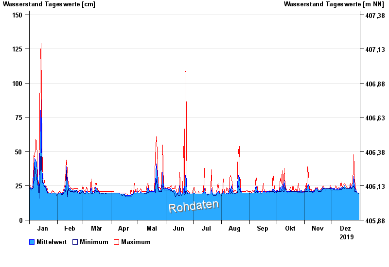
Chart of year Wolnzach / Wolnzach
Waterlevel from 01.01.2019 to 31.12.2019
Hinweis:
Der Wasserstand am Pegel wird durch Geschiebe nach Hochwasser beeinflusst.
- 30.08.2021 Wasserstand: 215 cm
- 13.06.2018 Wasserstand: 168 cm
- 26.08.2023 Wasserstand: 148 cm
- 17.08.2023 Wasserstand: 136 cm
- 14.01.2019 Wasserstand: 129 cm
| Date | Mean value [cm] | Maximum [cm] | Minimum [cm] |
|---|---|---|---|
| 31.12.2019 | 20 | 20 | 19 |
| 30.12.2019 | 20 | 20 | 20 |
| 29.12.2019 | 20 | 20 | 20 |
| 28.12.2019 | 21 | 21 | 20 |
| 27.12.2019 | 22 | 23 | 21 |
| 26.12.2019 | 24 | 29 | 21 |
| 25.12.2019 | 32 | 48 | 25 |
© Bayerisches Landesamt für Umwelt 2025